
 Cloud computing just made life a bit easier. The DOE's National Renewable Energy Laboratory (NREL) just released a tsunami of useful data. But its new interactive geospatial app allows anyone to easily and accurately map potential renewable energy resources throughout the United States - directly from their computer browser. And once you've played with this tool for a while, it becomes easy to see the vast riches of renewable resources in the US.
Go to RE Atlas, which is free and works within your web browser.
Cloud computing just made life a bit easier. The DOE's National Renewable Energy Laboratory (NREL) just released a tsunami of useful data. But its new interactive geospatial app allows anyone to easily and accurately map potential renewable energy resources throughout the United States - directly from their computer browser. And once you've played with this tool for a while, it becomes easy to see the vast riches of renewable resources in the US.
Go to RE Atlas, which is free and works within your web browser.
RE Atlas was designed to facilitate energy policy development, investment, and education by making high quality data accessible and easy to understand. The tool creates dynamic maps of renewable resources, including biomass, geothermal, hydropower, solar, and wind. These resources can be displayed individually or in a composite fashion.
Revealing the complex world of renewables
For example, it provides a map for photovoltaic resources, showing the best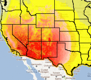 locations for PV solar panels (in yellow), and concentrated solar power (in red). A zoom function allows a search all the way to the county level.
Later you can even track down EPA designated contaminated sites.
Dan Getman, whose team in the DOE's NREL Strategic Energy Analysis Center developed the tool, stated, "Ease of use and breadth of data make RE Atlas an excellent tool for policymakers, planners, energy developers, and others who need to better understand the renewable resources available in the United States."
